Apalachicola
Lowstand Systems Tract
The lowstand systems tract is characterized by fluvial channels on the inner shelf and an absence of lowstand fans, slope canyons, and gullies in deeper water.
Due to the amalgamation of surfaces on the inner shelf, the lowstand systems tract is illustrated on isochron maps for highstand deposition (stage 5e to stage 2). The lowstand is illustrated by fluvial channel incision landward of lobate deltas on the middle/outer shelf.
During stage 7 to 6 time, fluvial-deltaic deposition persisted throughout the lowstand.
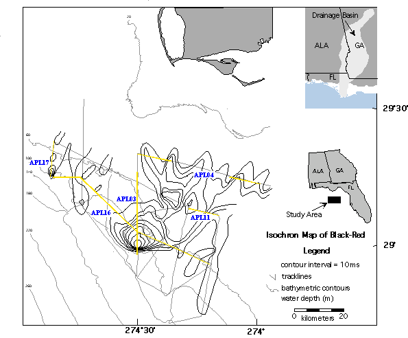
The isochron map "Isochron Map of Black-Red" illustrates thicknesses in time. The contour interval is 10 ms. This unit represents deposition between stage 5e and stage 2. Landward of the 60 meter isobath, the isochron map is characterized by fluvial incision associated with the lowstand (see line APL04), (see line APL16) and (see line APL11). The 60 meter isobath is the approximate location of the amalgamation of surfaces (see line APL16).
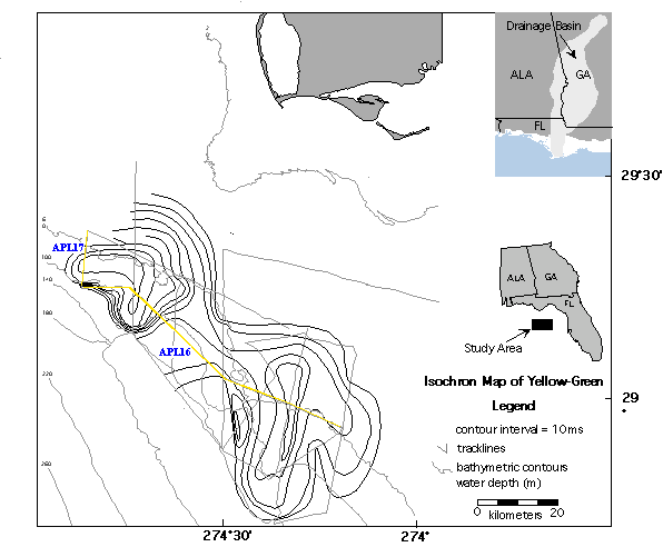
The isochron map "Isochron Map of Yellow-Green" illustrates thicknesses in time. The contour interval is 10 ms. This unit represents deposition between stage 7 and stage 6. The area of the delta (that portion with clinoform geometries) is represented by 2 distinct lobes. The area of the western lobe (that portion with clinoform geometries) is approximately 37 km wide, 34 km long, and up to 80 ms thick. The eastern lobe is approximately 38 km wide, 37 km long, and up to 40 ms thick. (The volume was estimated by approximating contour intervals with 3 diminsional geometric figures, subtracting out inside volumes, and summing.) Using a velocity of sediments equal to 1500 m/s, the sediment volume associated with the western lobe is approximately 31,600,000,000 m3 and the sediment volume associated with the eastern lobe is approximately 11,629,629,630 m3. The total sediment volume represented is approximately 43,229,629,630 m3 (43 km3).
Due to the lower accommodation, the deltas were forced to prograde the shelf rapidly in water depths between approximately -90 and -120 meters. This is an approximation and since topset beds are eroded by the stage 6 sequence boundary. According to the Haddad (1994) see level proxy curve for the last few glacial cycles, this represents deposition between 156 ky and 141 ky. Therefore, the depositional rate can be estimated at 2,881,975 m3/yr (.003 km3/yr) (3 km3/1000 yr).
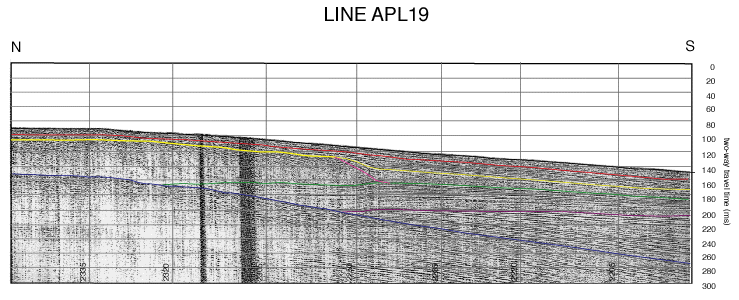
Seismic line APL19 illustrates the "ramp-style" margin (no distinct shelf-break). Seismic stratigraphic correlation suggests that the unit deposited between the yellow and red surfaces is part of the transgressive systems tract. This is seen onlapping the late highstand delta. The lowstand systems tract is not well defined with an absence of lowstand fans, slope canyons and gullies.
Comments, questions? Contact us at
gulf@gulf.rice.edu.