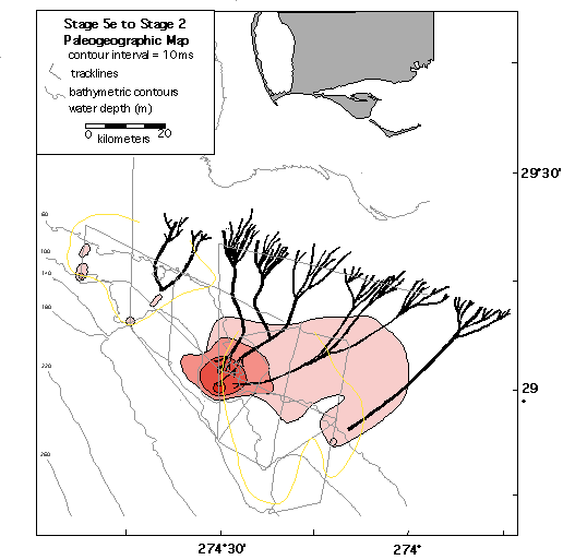
During deposition of the delta, sea level ranged from approximately -60 meters to -90 meters (see line APL03) with evidence of a forced regression illustrated by the western lobe (see line APL 17). According to the Chappell et al. (1996) sea level proxy curve for the last glacial cycle, this represents a relative still stand in sea level between 25 ky and 75 ky. Therefore, the depositional rate can be estimated at 896,771 m3/yr (.0009 km3/yr) (.9 km3/1000 yr).
The external morphology and internal facies suggest that deltaic deposition during this time was wave-dominated. There is a virtual absence of prodelta deposits (see line APL03). The yellow outline represents the limits of deltaic deposition associated with the prior glacial cycle (stage 7 to stage 6) (unit 2). Note that the younger delta (unit 1) filled antecedent topography between these older deltas. Fringing barriers, associated with unit 1, were formed at the offlap break of the older deltas (see line APL16). The younger deltas form distinct bathymetric protrusions on the modern seafloor (see line APL03). Their preservation is possibly attributed to hardground formation during the subsequent lowstand.
Fluvial incision associated with the stage 2 sequence boundary, suggests that channels generally deepen widen and converge offshore (see lines APL04 and APL11). Ultimately, a single trunk channel is formed that is steeper on its eastern side and shows terraces and a more gradual slope on its western side (see line APL11). This suggests a fluvial system which is migrating to the east. Composite channel fill suggests active channel migration (see line APL04).
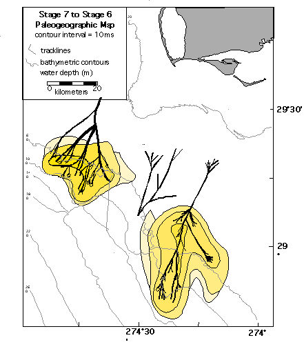
Due to the lower accommodation, the deltas were forced to prograde the shelf rapidly in water depths between approximately -90 and -120 meters. This is an approximation since topset beds are highly eroded by the stage 6 sequence boundary. According to the Haddad (1994) sea level proxy curve for the last few glacial cycles, this represents deposition between 156 ky and 141 ky. Therefore, the depositional rate can be estimated at 2,881,975 m3/yr (.003 km3/yr) (3 km3/1000 yr).
A well developed distributary system and active lobe switching, associated with the deltas, implies that they were fluvial-dominated (see line APL16). In addition, the external lobe morphology is elongate or "bird-foot" shaped suggesting that fluvial deposition overwhelms wave influence.
The stage 6 sequence boundary, capping the late highstand delta, is characterized by fluvial erosion (see surface yellow). Fluvial channels imaged in interlobate areas were formed during the early transgression (stage 6 to stage 5) and eventually fed the deltas associated with the last glacial cycle.