June 28, 2002
Report to the Texas General Land
Office
John Anderson and Julia Smith Wellner
Department of Earth Science
Rice University
Houston, TX, 77251-1892
713-348-4880
Texas beaches are experiencing rates of erosion that are among the highest in the continental U.S., averaging 5-6 ft/yr along the east Texas coast (1) and exceeding 10 ft/yr in certain locations. While this is close to the long-term (thousands of years) rate of coastal retreat, waterfront property owners are convinced that this erosion is unprecedented and they are demanding action. In the near future the problem will shift from one that concerns mostly beachfront property owners to one that threatens the economy of the state, and thus all Texans. The causes of the erosion include rising sea level, land subsidence, and a paucity of sand sources. Unfortunately, there is no obvious solution to the problem. The Texas inner continental shelf is comprised dominantly of mud; this is due in part to the circulation patterns in the Gulf of Mexico, pushing fine-grain sediments to the Central and East Texas coasts. Thus, it is not a simple case of pumping sand back onshore to replenish eroding beaches, as is the case in Florida and Alabama.
The underlying geology of coastal systems plays a large role in the development of those coastal systems (2). The antecedent topography, i.e., the base over which coastal systems develop, controls what type of features will develop and how thick those features will be. The erodability of the underlying substrate is a factor in how easily sediment can be obtained for a coastal system and what type of sediment will be produced. The antecedent topography and character of the substrate together control barrier island thickness, shoreface profile and thickness, and shoreline erosion rates. These geologic factors also control the location of offshore sand resources. For this reason, putting sand resource studies in the context of the geological setting of the area is critical for developing an ability to predict sand sources. Our sand resource studies follow on two decades of work on the Texas coast and continental shelf http://gulf.rice.edu
We have undertaken a study to compile lithologic
data from the East Texas inner continental shelf in order to identify potential
borrow sites. These data have been collected over two decades by the Rice
University Coastal Research Program and have been augmented by 20 new cores
from key sites. Data from over 250 cores have been put on a web site http://gulf.rice.edu/coastal
in order to facilitate distribution to any interested parties. Already,
coastal management firms have contacted our group about further access
to the dataset. The web site includes clickable maps of the core locations,
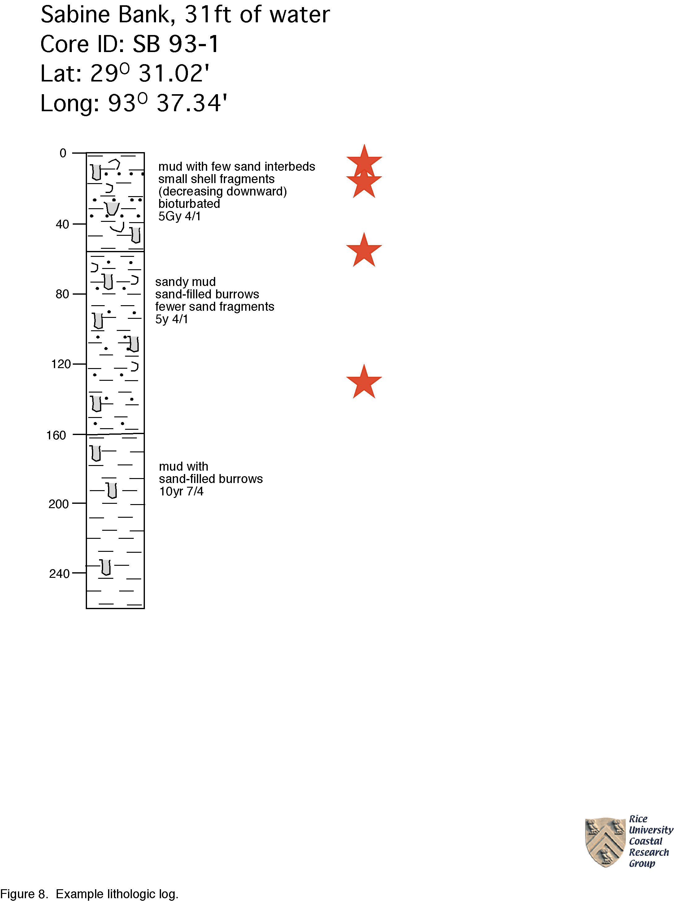
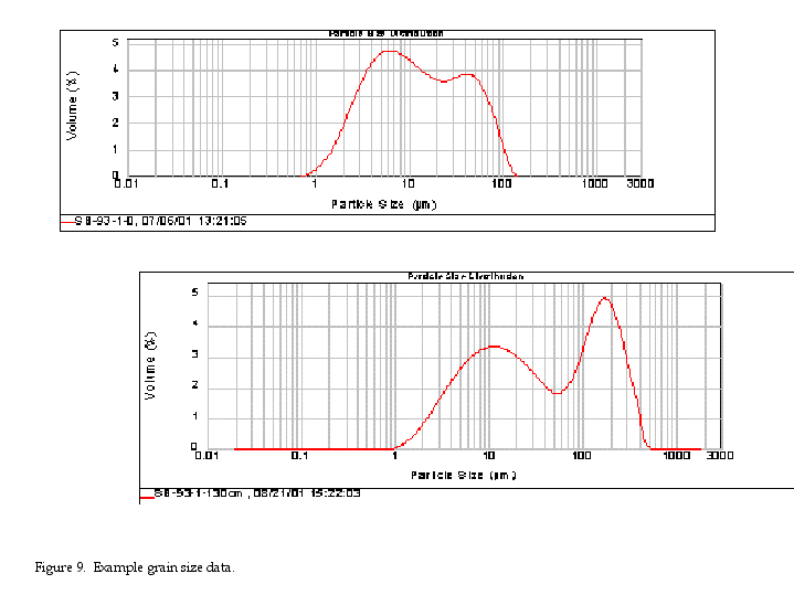
lithologic logs of each core, and detailed grain-size analysis from key
lithologic units. Figures 1 through
7 are maps showing the distribution of the core data. Figures
8 and 9 and
are a sample lithologic log and associated grain size data. The rest of
the lithologic data is available from the web site.
Near-Term Borrow Sites
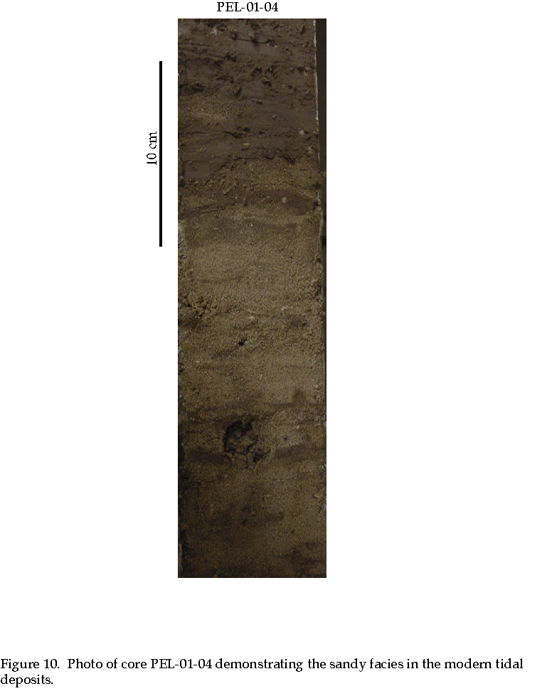
Two sites have been identified that could supply sand for relatively small nourishment projects. The first is the western side of the modern tidal delta in the entrance to Galveston Bay. This sand body is situated adjacent to Pelican Island and was identified in a series of 9 cores (Fig. 10) collected for this project. These cores are characterized by muddy sands, tidal deposits consisting of alternating sand and mud layers, shell hash, and mud. On the basis of these 9 cores and 6 sediment probes, the sandiest environment is situated on the east side of Pelican Island. The cores, despite being fairly sandy overall, indicate a highly variable environment. Thus, before this sand body is used for beach nourishment, further coring is required to obtain a more detailed understanding of the stratigraphy. Our estimates are that there is 500,000 m3 of high quality sand and up to 4 x 10⁶ m3 if the lower quality sand is included. An important attribute of this potential borrow site is its proximity to the east end of Galveston Island.
The second potential short-term borrow site is
the ancestral Bolivar Roads flood tidal delta and associated deposits landward
of the western portion of Bolivar Peninsula. While limited in aerial extent,
this sand body is thick (Fig.
11) . Three rotary drill cores were collected along Bolivar Peninsula
as past of this investigation, including one in Bolivar Canal, in order
to assess the thickness of this sand body. The Bolivar Canal core penetrated
28 ft of clean well-sorted sand. This borrow site is also close to Galveston
Island.
Long-Term Borrow Sites
When this project was begun, there was much discussion about the potential of Sabine and Heald Banks as potential borrow sites. Lithologic logs have been posted for these locations. The cores do indicate a somewhat sandy environment. However, the detailed grain size analysis (114 samples from Sabine Bank) show that the environment is characterized by a mix of sand, mud, and shell hash. Additionally, the area is far from shore and is in an important spawning ground for marine fishes. Thus, it does not seem to be a good resource for sand.
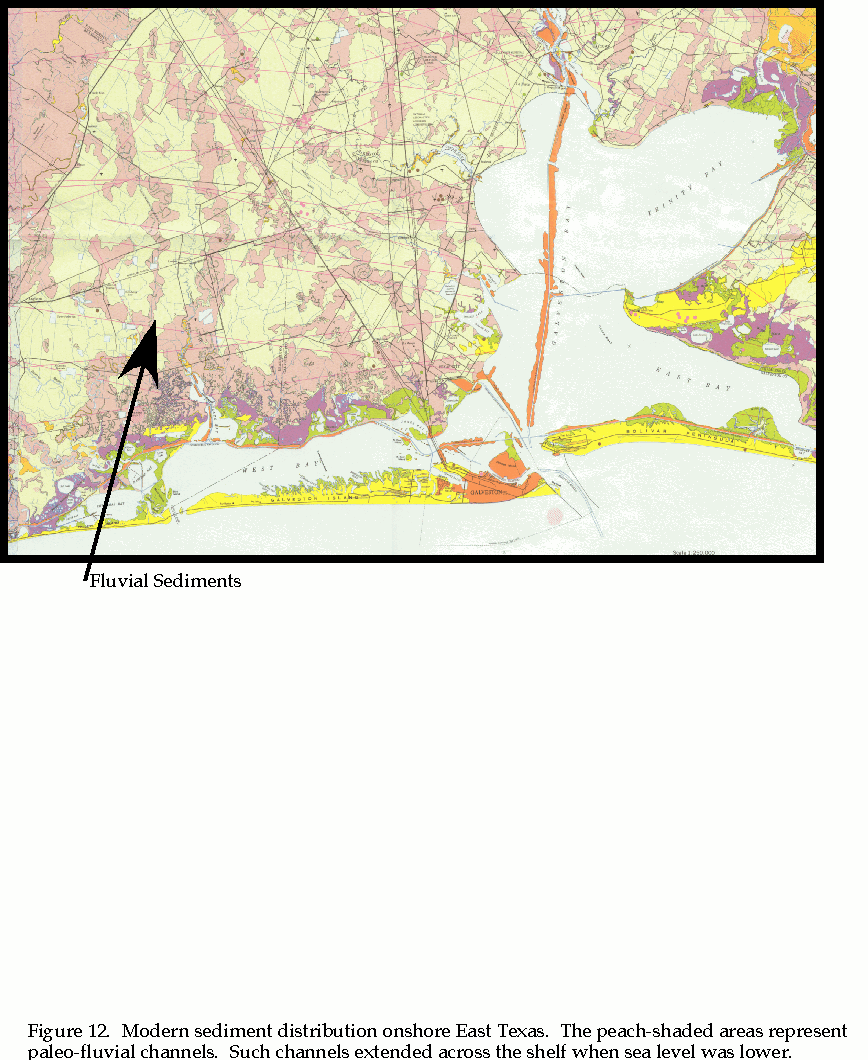
One other potential resource was identified for
long-term nourishment projects. This resource occurs across the shelf in
the form of paleo-incised valleys (Fig.
12) (see http://gulf.rice.edu/sandbodies/sandbodiesiv.html
for additional information). These valleys were carved by rivers during
the last lowstand of sea level. They are filled by a variety of fluvial
sediment that is believed to be sand-prone. This fluvial sediment is thought
to occur across the continental shelf in great abundance. Further analysis
is needed to delineate this resource.
Conclusions
Compilation of the data already obtained by Rice
University, with the addition of new cores in targeted locations, is an
effective way to evaluate potential borrow sites on the east Texas shelf.
Two sites have been identified for small-scale nourishment projects. Detailed
grain-size data for these sites has been posted on the web and is available
to the public. Borrow sites for long-term beach nourishment projects need
further study.
References
1. Heinz Center Report, 2000, Evaluation of erosion hazards, Federal Emergency Management Agency, http://www.heinzcenter.org
2. Rodriguez, A.B., Wellner, J.S., and Anderson, J.B., 2002, Geologic
controls on coastal erosion, Fourth Texas Coastal Issues Conference, Corpus
Christi, Texas, http://www.glo.state.tx.us/coastal/cic2002/index.html
Further Reading
Anderson, J.B., Rodriguez, A.B., Fletcher, C., and Fitzgerald, D., 2001, Researchers focus attention on coastal response to climate change: EOS, v. 82, n. 44, p. 513-520.
Anderson, J.B. and Siringan, F.P., 1992, Holocene sea-level rise and its impact on the evolution of East Texas coastal environments, Geological Society of America South Central Section Meeting, Field Trip Guide 5, February 23-25, 1992, Houston, Texas, 31p.
Anderson, J.B., Siringan, F.P., Smyth, W.C., and Thomas, M.A., 1991, Episodic nature of Holocene sea level rise and the evolution of Galveston Bay: in Coastal Depositional Systems in the Gulf of Mexico, Gulf Coast Section SEPM, Twelfth Annual Research Conference, p. 8-14.
Anderson, J.B., Siringan, F.P., Taviani, M., and Lawrence, J., 1991, Origin and evolution of Sabine Lake, Texas-Louisiana: Transactions of the Gulf Coast Association of Geological Societies, Volume 41, 12-16.
Anderson, J.B., Siringan, F.P., and Thomas, M.A., 1990, Sequence stratigraphy of the late Pleistocene-Holocene Trinity/Sabine valley system: relationship to the distribution of sand bodies within the transgressive systems tract, in J. Armentrout, ed., Sequence Stratigraphy as an Exploration Tool: Gulf Coast Section SEPM, Eleventh Annual Research Conference, p. 15-20.
Anderson, J.B., Thomas, M.A., Siringan, F.P., and Smyth, W.C., 1992, Quaternary evolution of the East Texas coast and continental shelf, in C.H. Fletcher III, and J.F. Wehmiller, eds., Quaternary Coasts of the United States: Marine and Lacustrine Systems, Project #274, Quaternary Coastal Evolution: SEPM Special Publication 48, Tulsa, Oklahoma, p. 253-263.
Cole, M.L. and Anderson, J.B., 1982, Detailed grain-size and heavy mineralogy of sands of the northeastern Texas Gulf Coast: implications with regard to coastal barrier development: Gulf Coast Geological Society Transactions, Volume 32, p. 555-563; reprinted in "Holocene Sediments of the Gulf of Mexico Basin," Readings in Gulf Coast Geology, v. 5, Gulf Coast Associations of Geological Societies, p. 105-114.
Rodriguez, A.B., Anderson, J.B., Siringan, F.P., and Taviani, M.,2000, Sedimentary facies and genesis of Holocene sand banks on the East Texas inner continental shelf, in J. Sneddin and K. Bergman eds., Isolated Shallow Marine Sand Bodies, SEPM Special Publication 64, Tulsa, Oklahoma, p. 165-178.
Rodriguez, A.B., Fassell, M.L., and Anderson, J.B., 2001, Variations in shoreface progradation and ravinement along the Texas coast, Gulf of Mexico: Sedimentology, v. 48, p. 837-853.
Siringan, F.P. and Anderson, J.B., 1993, Seismic facies, architecture, and evolution of the Bolivar Roads tidal inlet/delta complex, East Texas Gulf Coast: Journal of Sedimentary Petrology, v. 63, no. 5, 794-808.
Siringan, F.P. and Anderson, J.B., 1994, Modern shoreface and inner-shelf storm deposits off the East Texas coast, Gulf of Mexico: Journal of Sedimentary Research, v. B64, no. 2, 99-110.
Smyth, W.C., Anderson, J.B., and Thomas, M.A., 1988, Seismic facies analysis on entrenched valley-fill: a case study in Galveston Bay, Texas: Gulf Coast Association of Geological Societies Transactions, Volume 38, 385-394.
Thomas, M.A. and Anderson, J.B., 1988, The effect and mechanism of episodic sea level events: the record preserved in late Wisconsinan-Holocene incised valley-fill sequences: Gulf Coast Association of Geological Societies Transactions, Volume 38, 399-406.
Thomas, M.A. and Anderson, J.B., 1989, Glacial eustatic controls on seismic sequences and parasequences of the Trinity/Sabine incised valley, Texas Continental Shelf: Gulf Coast Association of Geological Societies Transactions, Volume 39, 563-570.
Thomas, M.A. and Anderson, J.B., 1994, Sea-Level Controls on the Facies Architecture of the Trinity/Sabine Incised-Valley System, Texas Continental Shelf, in R. Dalrymple, R. Boyd, and B.A. Zaitlin, eds., Incised Valley Systems: Origin and Sedimentary Sequences: SEPM Special Publication 51, Tulsa, Oklahoma, p. 63-82.