East Texas (Brazos/Colorado)
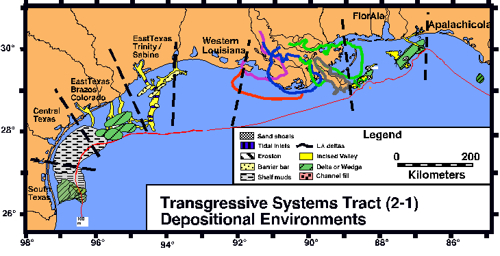
Transgressive Systems Tract
The Brazos/Colorado area has numerous transgressive deposits, including
backstepping deltas, incised valley fills, and a possible fluvial plain
sand bodies. The backstepping deltas are strike-aligned lenses, between
25 and 50 kilometers long, with chaotic to prograding clinoforms. They are bounded at the base by an erosional surface (ravinement surface)
and overlain by onlapping, continuous, parallel reflectors. The deltas
range in thickness, but are typically 15 meters thick. Sediment information
is limited, but scattered cores show a predominance of mud with some sands
in the distributary channels. The incised valley fills range from chaotic
to onlapping laminated seismic facies (1996 ISG report). The fill is underlain
by the sequence boundary and overlain by laminated marine muds or backstepping
deltas. Depth of incision varies but is on average 20 meters.
Platform borings and cores show that the chaotic facies corresponds to sandy
material, ranging in grain size from medium sand and gravel, with a Colorado
mineral signature. The laminated unit also fills the Brazos valleys, and
is thought to be mostly comprised of clay. The fluvial plain deposit is
an extensive strike-aligned deposit (~60 km) on the middle shelf. The unit
is underlain by the Stage 2 sequence boundary and capped by the ravinement
surface. The base is marked by numerous small channel incisions (depth varies
but from a few meters to about 7 meters) with chaotic to laterally accreting
fill. The overall deposit is approximately 10 meters thick. Cores and platform
borings show that the deposit is a clean, medium to fine sand with no marine
fossils.
During the last transgression, the Colorado River constructed a large, sandy delta on the inner shelf wich is designated the SFU F delta. The transgressive systems tract consists of backstepping deltas, reefs, and
possible transgressive incised valley fill deposits.
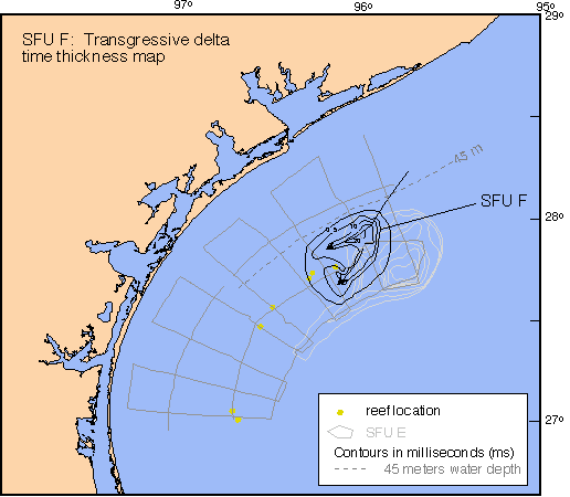
Time thickness map of SFU F. SFU F is in black and is located updip of SFU E (in gray).
This map only shows the most western lobe of the Phase 1 transgressive
delta mapped by Snow (1998). Arrows indicate ancestral Colorado distributary
channels. The timing of reef development can be constrained to be between 11,000 and
11,500 years BP based on the radiocarbon dates of the Phase 1 delta (Snow, 1998). The area south of the delta is carpeted by transgressive marine muds of the "Texas Mud Blanket" (Shideler, 1976). These muds onlap and bury sandy highstand coastal deposits.

Comments, questions? Contact us at
gulf@gulf.rice.edu.