The study area is located on the middle and outer Florida shelf in water depths ranging from 30 meters to 150 meters. The survey area is between 85 degrees and 86 degrees west longitude and 28 degrees 45 minutes and 29 degrees 45 minutes north latitude. This area is offshore Apalachicola and Panama City, Florida.
The study area is unique for its drainage basin and shelf characteristics (see Drainage Basin Characteristics).
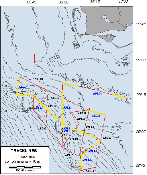
As part of this study, approximately 550 kilometers of high resolution seismic data were collected; sediment samples from the near-surface were collected from locations APL3 and APL4, the ancient alluvial valley, and Panama City Beach; and a single short core was collected from APL5.
There is no
chronostratigraphic control
for this area. Age relationships are based on stratal stacking relationships, relations to bounding surfaces, and correlations to sea level curves. Similar studies, included in this web site, have shown this method reliable.
Map is clickable.
 Shelf Bathymetry Characteristics
A ramp-type setting with a relatively steep gradient (0.2 meters/kilometers on the inner shelf and 0.9 meters/kilometers on the outer-shelf)
Low subsidence
No prominent shelf break
Irregular inner-shelf bathymetry (above 40 meters) consisting of sand ridges associated with the last transgression (stage 2 to stage 1)
Distinct protrusions of the shelf edge trend at approximately 100 meters water depth
Virtually flat upper slope bathymetry due to an absence of slope gullies and canyons
Highstand Systems Tract
Lowstand Systems Tract/Deep Water
Transgressive Systems Tract
Time Structure Maps
Paleogeography
Conclusions
For a more detailed discussion see McKeown et al (2004).

Comments, questions? Contact us at
gulf@gulf.rice.edu.