South Texas
Transgressive Systems Tract
The Tst consists of four seismic facies units and one important erosional surface. The oldest Tst seismic facies unit, Tst 1, is shown in the isochron map below.
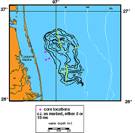
Tst 1 overlies either the Stage 2 to 1 transgressive surface alone or that surface amalgamated with the Stage 2 sequence boundary. Tst 1 underlies either a deformation surface (Tste) or the sea floor. The isochron of Tst 1 displays two main features: a shore perpendicular fill feature in the south (Tst 1A) and a fan-shaped mound in the north (Tst 1B).
Tst 1A
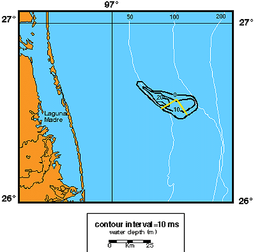
Tst 1A is approximately 20 km in width and extends greater than 25 km offshore (the transgressive surface cannot be traced reliably further east, but the deposit probably does extend further). The maximum thickness of Tst 1A is approximately 20 ms (15 m). Dip line 15 and strike line 16/116 provide seismic examples of this feature. The seismic lines display the subparallel reflection configuration of Tst 1A that overlies Stage 2 to 1 transgressive surface and underlies the sea floor. Tst 1A deposits are located in topographic lows created by incision associated with the Stage 2 sequence boundary.
Two lithologic descriptions (SP-7 and SP-2) are available of Tst 1A. A generalized core transect is also available.
Based on Tst1A's position overlying lowstand delta plain deposits, the subparallel reflection configuration, and the lithologic information, the unit is interpreted as an abandoned delta plain deposit.
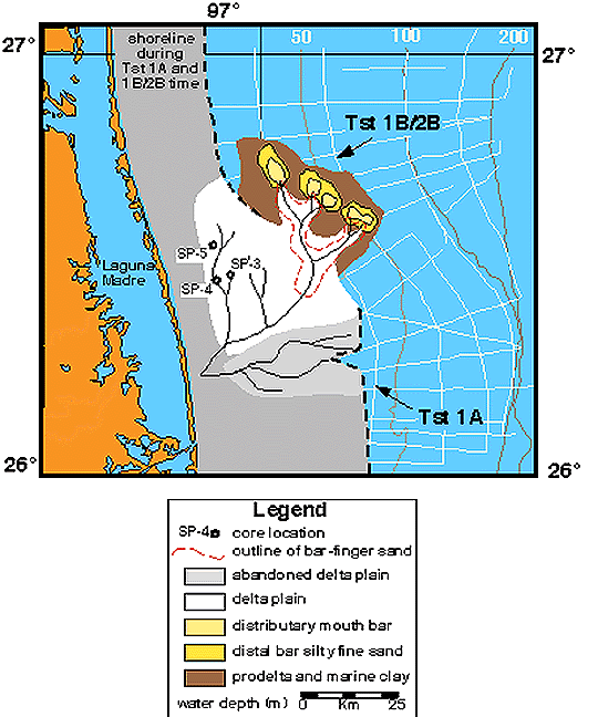
Tst 1B
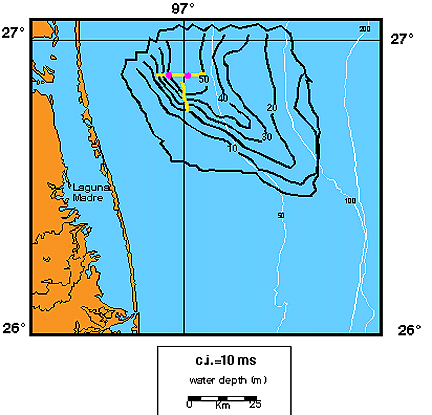
The fan-shaped mound Tst 1B is approximately 50 km in width and extends seaward 30 km. The deposit has a maximum thickness of 30 ms (22.5 m). On seismic lines 331 and 16ab, Tst 1B overlies the amalgamated Stage 2 sequence boundary and Stage 2 to 1 transgressive surface and underlies a localized deformation surface (Tste). Line 331 is a dip line from the middle shelf in the central part of the study area.
Three lithologic descriptions exist for Tst 1B (SP-3, SP-4, and SP-5), as well as a core transect.
Tst 1B is interpreted as part of a delta based on the oblique tangential prograding clinoforms. Based on the structural relationships with the overlying unit, the lobate fan-mound isochron geometry, and the lithologic data the unit is interpreted as an elongate fluvially-dominated delta.
Tste
Tste separates Tst 1B and Tst 2B and is characterized by localized deformation.
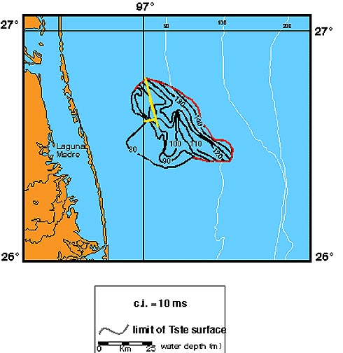
The time structure map displays a prominent north to south striking topographic low. Dip line 11b, from the inner shelf in the central part of the study area, displays how the overlying Tst 2 unit cuts into the underlying Tst 1B. Strike line 16ab, also from the inner shelf in the central part of the study area, demonstrates an example in which to the south Tst 2B cuts into Tst 1B and to the north Tst 2B conformably overlies Tst 1B.
Tst 2
The second oldest seismic facies unit in the transgressive systems tract is Tst 2. Tst 2 overlies either Tste, the Stage 2 to 1 transgressive surface, or Tst 1 and underlies the Tst 3 unit, Tst 4, or the sea floor.
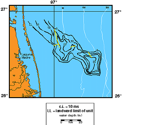
The isochron of Tst 2 strikes northwest to southeast across the width of the shelf. It is characterized by two mounded features. These mounds are located in approximately 50 to 110 m of modern water depth (Tst 2A) and 35 to 70 m (Tst 2B), respectively.
Tst 2A
Tst 2A is approximately 30 km in width, 25 km in length, and 30 ms (22.5 m) in thickness. Seismic line 36a displays a strike perspective through Tst 2A. The line demonstrates the complex sigmoid oblique character of the unit that in this location overlies the Stage 2 to 1 transgressive surface and underlies both Tst 3 and Tst 4. The upper boundary of Tst 2 is modified by erosion. There seems to be more lateral shifting during transgressive time than during lowstand or highstand times. No lithologic information exists for unit Tst 2A. Based on the prograding clinoform pattern, the unit is interpreted as a delta. The elongate to lobate mound geometry, the smooth, regular pattern of the isochron contours, and the location of the deposit on the outer shelf during a sea level rise suggest that this is a wave-dominated delta.
Tst 2B
Lines 11b, 331, and 16ab provide examples from Tst 2B. The internal shape of this mounded form is quite interesting. The geometry suggests a channel fill origin. Line 11b demonstrates the chaotic fill reflection configuration of the deposit overlying the Tste on the inner shelf. Line 16ab provides a dip-oblique perspective of Tst 2B from the inner shelf. The southern portion of Line 16ab displays the chaotic fill reflection configuration of Tst 2 as it fills a large incision in the underlying Tste. The northern portion of Line 16ab demonstrates a shingled prograding clinoform reflection configuration as the Tst 2 unit downlaps the Tst 1 unit. Line 331 provides an oblique view of Tst 2 from the middle shelf. Although the patterns are not as clear on Line 331 as 16ab, they are similar. The western portion of Line 331 displays a chaotic reflection while further to the east, a low angle, shingled prograding clinoform reflection configuration is present. The Tst 2 unit fills in the topography of the underlying Tste surface and then extends to the sea floor or is onlapped by deposits of the younger Tst 3 or Tst 4 units. No lithologic information exists for unit Tst 2B. Based on the geometry of the Tste surface, the Tst 2B isochron pattern, and the chaotic and shingled clinoform reflection configurations the unit is interpreted as part of an elongate fluvially-dominated delta, or a high-constructive-elongate delta.
Tst 3
Tst 3 is a small unit (approximately 40 km in strike and ranging from 4 to 17 km in dip) that strikes northwest to southeast (similar to the underlying unit Tst 2). The unit is located between 70 and 130 m of modern water depth. Seismic line 33a presents an oblique dip view of Tst 3 that demonstrates a sigmoid progradational reflection configuration. Tst 3 overlies the amalgamated Stage 2 sequence boundary and Stage 2 to 1 transgressive surface or simply the transgressive surface. Unit Tst 3 is onlapped by the deposits of Tst 4. Seismic line 36b provides an oblique view of unit Tst 3 that displays an oblique tangential progradational reflection configuration pattern. Tst 3 downlaps the Stage 2 to 1 transgressive surface while overlying Tst 4 reflections onlap the upper boundary of Tst 3. The upper boundary of Tst 3 is deeper than the upper boundary of Tst 2. The unit is interpreted as a delta based on the prograding clinoform reflection configuration. The smooth, regular pattern of the isochron contours, the arcuate, elongate lens geometry, and the location of the deposit on the outer shelf during a sea-level rise suggest that this is a wave-dominated delta.
Tst 4
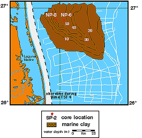
Tst 4 is the youngest seismic facies unit in the transgressive system tract. Tst 4 spans the entire shelf in the northern portion of the study area with deposits in modern water depths of 25 to 100 m.
The southern boundary of the unit trends northwest to southeast. Tst 4 is approximately 85 km in strike and 70 km in dip with a maximum thickness of approximately 50 ms (37.5 m).
Seismic lines 16ab and 3 demonstrate onlapping fill reflection configuration pattern of Tst 4 as the unit onlaps the upper boundary of Tst 2. Tst 4 is filling a large amount of accommodation space in the northern portion of the study area. The upper surface of Tst 4 is the sea floor. Tst 4 also contains several carbonate mounds.
Two lithologic descriptions (NP-6 and NP-8) and a core transect of unit Tst 4 are available. Tst is interpreted as an offshore marine deposit based on fill geometry, onlap and downlap fill reflection configurations, and lithologic information.

Comments, questions? Contact us at
gulf@gulf.rice.edu.